Version History
Here you can find the changelog of Planit Pro: Photo Planner since it was posted on our website on 2016-09-24.
The latest version is 10.5.3 and it was updated on soft112.com on 22 April, 2024.
See below the changes in each version:
version 10.5.3
posted on 2024-04-01
Apr 1, 2024
Version 10.5.3
I would like to dedicate this release to Alyn Wallace, who has been a tremendous supporter of Planit Pro. Since he began sharing the app with his audience eight months ago, his impact has been immense. Although we never had the chance to meet or speak personally, his contribution has been invaluable. Rest in peace, Alyn!
Some bug fixes.
version 10.5.2
posted on 2024-03-18
Mar 18, 2024
Version 10.5.2
Fixed syncing markers with pictures were not working.
Several bug fixes.
Fixed the camera heatmap was not cleared correctly.
The admin feature for the Landmark Locations is done.
If you are familiar with the local area and want to be the Admin to contribute to the Landmark Locations feature, please contact us.
Fixed small models not showing.
version 10.4.24
posted on 2023-12-14
Dec 14, 2023
Version 10.4.24
We will resend the verification email if the account is not yet verified when the user tries to login or reset password.
Only show the past task markers within a year on the map.
Added a setting button on the top left of the map, tap to open map category settings, press and hold to open all settings.
Added a show/hide markers added by you setting which allows you to hide all the markers so that the map content is fully visible.
Fixed a bug when syncing the plans and markers.
Added ferries wheel, pole, boat and train marker types.
Added has picture filter buttons to the marker list page.
Added curved cone (cco), curve frustum (ccf) and pagoda (pgd) to OBJ language.
version 10.4.23
posted on 2023-10-08
Oct 8, 2023
Version 10.4.23
Show a center at scene button on the viewfinder if needed which can be used to quickly get back to the main subject.
Fixed adding a reminder not working on iOS 17.
version 10.4.22
posted on 2023-10-01
Oct 1, 2023
Version 10.4.22
Adjusted the display of sunrise/sunset/moonrise/moonset lines to text to make it easier for beginners to understand the meaning of those lines, can be changed back under Settings - Ephemeris - Rise and set directions on the map.
Added new settings under Settings - Ephemeris - Shadows for building markers to hide the shadows for building markers.
Added VIIRS2022 dark sky layer.
Fixed buttons on the viewfinder not working on iOS 17.
version 10.4.21
posted on 2023-08-22
Aug 22, 2023
Version 10.4.21
Added a new comet C/2023 P1 (Nishimura).
version 10.4.20
posted on 2023-08-07
Aug 7, 2023
Version 10.4.20
Fixed a bug when calculating the subject height from a marker.
version 10.4.19
posted on 2023-04-19
Apr 19, 2023
Version 10.4.19
Fixed the sun and moon position are not touching each other for a partial solar eclipse.
version 10.4.18
posted on 2023-03-18
Mar 18, 2023
Version 10.4.18
Added 4x4+diagonal grid line in viewfinder as some Sony cameras have this grid line type as Diag + Square Grid.
Fixed the VR display issue when the elevation angle is high (such as eclipse where the Sun or the Moon position seem wrong when they should touch each other).
Added a comet C/2023 A3 (Tsuchinshan-ATLAS), possible to be very bright next year.
Fixed the wrong elevation is used for alignment search.
version 10.4.9
posted on 2022-07-27
Jul 27, 2022 Version 10.4.9
Supports scaling the model by width and height independently when importing or editing the model.
Supports oval base for cy, co and cf.
Dof tool now supports focusing on infinity.
Press and hold on the cloud that blocks the Sun/Moon/MWC will copy the coordinates so that you can paste it to a cloud map app to check the cloud at that location.
Refresh the shadow display by seconds.
Fixed searching UTM format not working.
version 10.3.4
posted on 2022-04-25
Apr 25, 2022 Version 10.3.4
Fix for the crash when upgrading to the previous version.
version 10.3.2
posted on 2022-04-15
Apr 15, 2022 Version 10.3.2
Fixed the color command creates the wrong color in the obj extension language.
Fix for the crash when upgrading to the previous version.
Fixed the location explorer settings were not saved to the shared plan file.
Fixed the alignment position cannot select Top.
version 10.2.5
posted on 2022-03-21
Mar 21, 2022 Version 10.2.5
If you open a plan without any tasks, you can use the save as button under the rename plan dialog to save the new change after opening the plan as a new plan so that the existing plan is not changed.
Added an option under Settings - Map to disable the long press to drag the marker to avoid accidentally change the marker position.
Fix a crash in some dates when showing the yallop value .
You can long press the target height on the ephemeris page to adjust the height using a slider.
Fixed the small hint texts are not shown correctly on some ephemeris pages.
Fixed a bug that the markers won't show up on the map.
version 10.2.1
posted on 2022-02-24
Feb 24, 2022
Version 10.2.1
Fixed exporting the obj extension model as a marker file doesn't remember the new grammar.
Fixed crash when downloading plans from server.
Fixed the tag for the marker is not committed if ENTER is not pressed.
version 10.2.0
posted on 2022-02-07
Feb 7, 2022 Version 10.2.0
Fixed the focal length precision and the wrong ephemeris page issues when sharing the plan between iOS and Android.
Introduced the obj extension version 2 to simplify the grammar where the starting vertex of each shape is defaulted to the default origin vertex or the vertex defined in the immediately preceding line so there is no need to write the vertex index for each shape, see the edit model page for more details.
Added a new "color" command to allow you to define the color of the material using "color r g b" where the r g b are a value between 0..255 or "color #RRGGBB" where the RR GG BB are two-digit heximal of the rgb value.
Fixed the plan list is not updated to reflect the latest task information if the task was updated or deleted.
version 10.0.5
posted on 2022-01-18
Jan 18, 2022 Version 10.0.5
Add two new shapes Dome (do) and Torus (to) to the 3d model obj extension language.
Changed the mesh structure for the sphere shape.
The sphere's parameters are also changed to allow different radii at the x, y and z directions and the step because the last parameters only if the three radii are present.
Added temperature and air pressure parameters under Settings - Ephemeris to refine the ephemeris calculation.
Prevents users from choosing the one-way download option when there are no plans or markers on the server in which case it will cause the local data to be deleted.
version 10.0.1
posted on 2022-01-07
Jan 7, 2022 Version 10.0.1
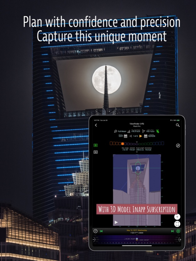
Introduce 3D model subscription which includes the access to more than three thousands markers with 3d models on the map as well as in the VR viewfinder, the ability to import your own 3d model and publish markers to share them with other users.
Added Apple Map.
Uses database to store all the plans and markers. Introduced a new task concept where each plan can have as many tasks as you want. You can interpret a task as a sub-plan or a finished plan. Plan will be saved automatically all the time. Task will only be saved when you press the save button. All markers are global markers, no more local markers under each plan.
You can now register and login to your account where you can sync the plans and markers to the server and to sync across different devices.
Support the joystick control for the markers. While selecting a marker on the map, you can press and hold the edit marker button (the one with a pencil icon) to show the joystick control. Support moving the marker using the joystick.
Support importing kml and gpx files with tracks, each track will become a marker on the map and selecting the marker will show the track on the map.
Added four drawing tools - polyline, polygon, extended line and double circle - each tool has its own unique usage (3d model subscription is needed).
Marker supports pictures and tags.
version 3.7.10
posted on 2021-06-06
Jun 6, 2021 Version 3.7.10
Fixed a UI display issue with iPhone 12.
Fixed the timezone is not updated bug with the last release.
For the marker category, added a new camera location category and removed the old number category.
The number category markers will be changed to general markers and the marker's setting will be adjusted automatically so that the number will still be shown on the marker icon.
Marker can be configured to show up to 2 letters of the marker title (if the title is more than 2 letters, use "|" to separate them) on the marker icon (in addition to the numbers before) if you choose general category and check Show Name on the Map.
version 3.7.8
posted on 2021-06-02
Jun 2, 2021 Version 3.7.8
Fixed a wrong value in the EV list.
Added Show Name on the Map option to the marker.
Added a few wide screen format to the panorama ratio.
version 3.7.7
posted on 2020-09-24
Sep 24, 2020 Version 3.7.7
Fixed the twilight wrong bug in some areas.
Added long press the choice buttons to set the start and the end time on the timelapse and sequence pages.
Fixed a bug that the sun/moon finder page will change the time.
version 3.7.6
posted on 2020-09-13
Sep 13, 2020 Version 3.7.6
Long press on the + button to add a marker and paste the content if it was copied earlier.
Long press on the viewfinder button to start VR viewfinder which is the most used viewfinder.
Tap on the shadow value on the Light and Shadow page to show and hide shadows of the buildings.
version 3.7.4
posted on 2020-07-31
31 Jul 2020 Version 3.7.4
Fixed the elevation angle limitation in AR.
Fixed several elevation related bugs in VR.
version 3.7.4
posted on 2020-07-31
Jul 31, 2020 Version 3.7.4
Fixed the elevation angle limitation in AR.
Fixed several elevation related bugs in VR.
version 3.7.3
posted on 2020-07-25
Jul 25, 2020 Version 3.7.3
Fixed failed to get the elevation in some locations.
version 3.7.0
posted on 2020-07-15
Jul 15, 2020 Version 3.7.0
Added Comets and Asteroids under Stars and Star-trails and visualize the their position in the viewfinders.
Upgraded the planit's elevation server to 30-Meter SRTM, the offline elevation remains at 90-Meter SRTM for now.
Improved the offline elevation page.
User now can download offline elevation for a region on the map without opening the VR first.
Added extra suggested exposure values for solar eclipse.
Allow tapping to select a marker even if the marker is under the green fan of the focal length tool.
Do not draw the milky way information on the time slider for non-milky way pages if showing the milky way setting is off.
Prompting a dialog to enter latitude and longitude if user enters invalid values.
Fixed a summer time bug in Chile.
We will use Google or Bing map key provided by you in the settings to use Google or Bing timezone web services when the location is near the edge of a timezone change because their web service is more accurate in this case.
Do not ask for the current location access unless you click on the current location button.
Added Done button to all any setting pages.
Added unit toggle switch to all the height and duration input dialogs.
version 3.6.18
posted on 2020-06-18
Jun 18, 2020 Version 3.6.18
Fixed a crash in the tools setting.
Fixed Google Streetview does not work.
version 3.6.17
posted on 2020-06-16
Jun 16, 2020 Version 3.6.17
Fixed press and hold on the sequence start time does not change the time.
Added the AMap and Baidu Map support for the eclipse overlays in addition to the Google Map.
Added the AMap support for the dark sky overlay.
version 3.6.15
posted on 2020-06-06
Jun 6, 2020 Version 3.6.15
We had made some great progress in supporting other languages. Finished Korean support, thanks Hogyu Kim. Finished Dutch support, thanks Tom Jacobs. Both are complete translations of the whole app. Some other languages such as Germany, Spanish, French, Italian, Russian were partial translated before but also were reviewed again by real people. You can find out who these people are in the About page of the app. If you are willing to help to translate to your own language, please let us know.
Added focus stacking support in the DoF tool, tap on the last label to select the focus stacking, then press and hold to see the focus stacking details.
Added row alternative colors to all the lists.
version 3.6.14
posted on 2020-06-03
Jun 3, 2020 Version 3.6.14
Adjusted the network timeout longer to avoid timeout errors for the dark sky data and the Bing elevation data
Fixes crashes when starting on the dark sky page
Fixed the info window position is not updated when hiding the ephemeris pages
version 3.6.12
posted on 2020-05-31
May 31, 2020 Version 3.6.12
Added World Atlas 2015 and VIIRS layers to Dark Sky
Updated solar eclipse kml files
Fixed exception showing the video tutorial for VR
Change xxx to 1/xxx" for shutter speed to avoid confusion
When choosing overlap percentage, added recommendation percentage for the day-time and night-time panoramas
Fixed the wrong distance values in the elevation gain page
Set the date as well when long pressing on the eclipse times to set the time-lapse and sequence starting and ending time
Fixed long press on set camera button does not always release the camera pin
Improved the sort performance of the plan or marker file list
Fixed the bug that the date picker in the wrong locale
version 3.6.11
posted on 2020-05-24
May 24, 2020 Version 3.6.11
Fixed the orientation sensor not working issue since the last release.
Improved the Russian translation. Thank Sergey Louks for spending a lot of time reviewing the translation.
Fixed the save button size too small on the menu for some languages.
A lot of fixes related to different languages.
Fixed the first day in week setting is not respected in this week choice of Finder.
Reversed the elevation angle and azimuth in the focal length tool so that it is consistent with other places.
version 3.6.10
posted on 2020-05-21
May 21, 2020 Version 3.6.10
Fixed a regression in the calendar where the month is wrong.
Added 13 more languages. Most of them are machine translated for now while waiting to be manually reviewed.
To be consistent, we will use the English way to format all the numbers, meaning the decimal point will be “.”, not “,” for all languages.
Adjusted the animation speed based on the viewfinder focal length when clicking on the Play button.
Adjusted the elevation range to -90 to 90 degrees in the Sun/Moon Finder.
Added Bing search option, again, need a Bing map key, which is shared by the Bing elevation service.
Fixed the timezone error when loading a picture with EXIF.
Extend the year range to from 0001 to 9999.
Show the azimuth values in the date time slider.
Fixed intermittent crashes when rotating the map.
Fixed the rainbow painting issue at both ends in the VR.
Fixed deleting files not working when the iCloud is enabled.
Fixed a panorama viewfinder drawing regression.
Fixed a regression in the calendar where the month is wrong.
version 3.6.9
posted on 2020-05-19
May 19, 2020 Version 3.6.9
Added 13 more languages. Most of them are machine translated for now while waiting to be manually reviewed.
To be consistent, we will use English way to format all the numbers, meaning the decimal point will be “.”, not “,” for all languages.
Adjusted the animation speed based on the viewfinder focal length when clicking on the Play button.
Adjusted the elevation range to -90 to 90 degree in the Sun/Moon Finder.
Added Bing search option, again, need a Bing map key, which is shared by the Bing elevation service.
Fixed the timezone error when loading a picture with EXIF.
Extend the year range to from 0001 to 9999.
Show the azimuth values in the date time slider.
Fixed intermittent crashes when rotating the map.
Fixed the rainbow painting issue at both ends in the VR.
Fixed deleting files not working when the iCloud is enabled.
Fixed a panorama viewfinder drawing regression.
version 3.6.8
posted on 2020-04-28
Apr 28, 2020 Version 3.6.8
Revised the realistic milky way. It now supports the panorama and picture viewfinders.
Reverted the previous change to the google search as it produces less results and not free after all. You would still need your own key to use the google search as before.
Revised the Settings screen. Too many entries so we divided them into seven categories and multiple screens.
Added the timezone in Add a reminder.
Fixed so that the shadow is drawn on the scene pin on the Light and Shadow page.
Fixed a bug that some texts got truncated when the bold text option is turned on in the iOS settings.
version 3.6.7
posted on 2020-04-21
Apr 21, 2020 Version 3.6.7
Fixed crashes in the VR.
Fixed AR showing a blue color.
Fixed crashes when opening settings from DoF, NPF/CoC rule.
Reversing order if entering the latitude and longitude in the wrong order when searching.
Adjusted the night sky color darker in the VR.
version 3.6.6
posted on 2020-04-18
Apr 18, 2020 Version 3.6.6
Shows photorealistic milky way in the VR viewfinder.
Fixed timezone issue in some area.
You can again use Google Search to search for locations even without your own Google map key.
Fixed a bug that in the panorama time-lapse simulation, the azimuth is not changing.
When selecting the camera or the scene pin, there is height associated with it, the height button will show in green so that you didn’t forget the height that was set from the previous plan which may not apply in the current plan.
Fixed a bug the star-trail starting time was reset when changing the ending time.
Set large print option to true and camera megapixels to 45MB by default in the settings. CoC, NPF and DoF will use these default settings to calculate. You can still change it back in the settings but we felt it makes sense to use a higher standard to calculate by default due to the camera advancement recent years.
Reorganized the settings screen, remove some uncommon ones, changed some order.
Added a furthest distance setting to allow user set how far the ground contour is drawn.
version 3.6.5
posted on 2020-04-10
Apr 10, 2020 Version 3.6.5
Changed the Light and Shadow page to use the camera location (used to use scene location) to calculate the ephemeris information, except the light elevation and the light condition which will still use the scene location to calculate as before. So all 19 ephemeris pages are consistently using the camera location now. However, it is possible you see the sun/moon elevation on the Light Elevation is different from other places for the aforementioned reason.
Fixed crashes on iOS 10 when opening VR.
Fixed wrong elevation data for some locations in China.
The companion app Planit Live (wait for 1.2.0 release) will an AR feature that is built on top of Apple's ARKit. It will replace the AR feature in the Planit Pro in the future. The Planit Live app is free to all users and no ads.
version 3.6.4
posted on 2020-04-08
Apr 8, 2020 Version 3.6.4
Fixed a regression in the last release which draws the moon at a wrong position.
Fixed a bug that it keeps prompting the iCloud Drive integration after choosing Later. Even so, we still suggest you enable iCloud Drive integration to avoid data loss due to accidental app uninstallation or phone loss.
Fixed crash when dragging a marker on MapBox.
For new users, do not show the sun/moon hourly track by default as they make the screen busy. You can still enable them in the settings.
Other small bug fixes
The companion app Planit Live now has an AR feature that is built on top of Apple's ARKit. It will replace the AR feature in the Planit Pro in the future. The Planit Live app is free to all users and no ads.
version 3.6.2
posted on 2020-03-11
11 Mar 2020 Version 3.6.2
Show an explanation message when turning on the iCloud integration switch in the settings if while the iCloud Drive is not enabled.
Fixed opening marker files didn't download them when they are still on the iCloud Drive.
Fixed the ground contour not showing when they are outside the viewfinder.
version 3.6.2
posted on 2020-03-11
Mar 11, 2020 Version 3.6.2
Show an explanation message when turning on the iCloud integration switch in the settings if while the iCloud Drive is not enabled.
Fixed opening marker files didn't download them when they are still on the iCloud Drive.
Fixed the ground contour not showing when they are outside the viewfinder.
version 3.6.1
posted on 2020-03-01
Mar 1, 2020 Version 3.6.1
Support iCloud Drive integration. It will prompt to be enabled when you run the new version for the first time or you can enable it in the settings.
Fixed a timezone error for Easter Island, Chile.
version 3.6.0
posted on 2020-02-03
Feb 3, 2020 Version 3.6.0
Added the undo/redo feature, the two buttons are under the “+” action button on the bottom right.
Other bug fixes.
version 1.95
posted on 2015-01-23
version 3.7.7
posted on 1970-01-01
2020年9月24日 Version 3.7.7
Fixed the twilight wrong bug in some areas.
Added long press the choice buttons to set the start and the end time on the timelapse and sequence pages.
Fixed a bug that the sun/moon finder page will change the time.
version 3.6.18
posted on 1970-01-01
2020年6月18日 Version 3.6.18
Fixed a crash in the tools setting.
Fixed Google Streetview does not work.
version 3.6.16
posted on 1970-01-01
13 de jun de 2020 Version 3.6.16
Added version history under the Menu.
Allow the temporary red marker for the selected location to be dragged.
Adjusted the sun and moon finder algorithm to get more accurate results.
Fixed a bug when the moonrise and moonset times were not calculated correctly because of summer time.